Speeches Shim
As demand for water rises and the risk from climate variability increases in Tanzania, efficient water resource management has become critical to guaranteeing sustainable use of these vital resources. Decision making for sustainable management of water resources is dependent on access to accurate and reliable weather, climate data and its impacts on water resources.
Building a Network of Citizen Science Partners
Hydroclimate (rainfall, temperature, wind, humidity, and evaporation) data are fundamental to climate risk analysis and management decisions for surface and groundwater resources. However, the availability of this data in Tanzania is impeded by a limited hydroclimate monitoring network. Data acquisition and management is expensive and exceeds the current resources of many Tanzanian Basin Water Boards (BWBs) responsible for management of this equipment. The USAID Water Resources Integration Development Initiative (WARIDI) introduced a citizen science approach to help the Wami-Ruvu and Rufiji BWBs address these constraints.
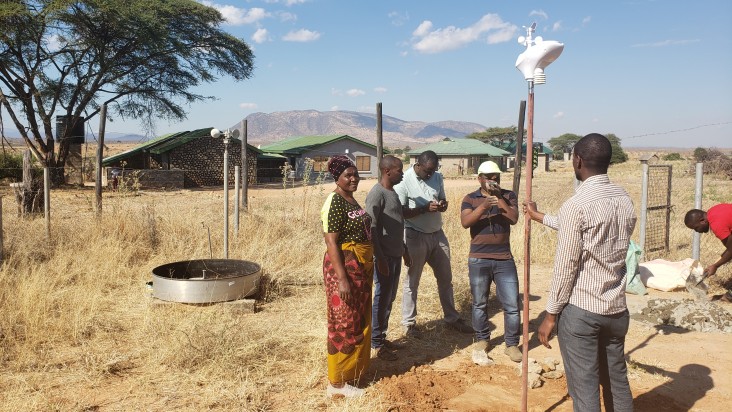
The Wami-Ruvu and Rufiji BWBs are working closely with public and private partners including schools, farms, a national park, tour operator, industry, and water utilities to install and operate a network of 34 low-cost hydroclimate stations (20 in Rufiji Basin and 14 in Wami-Ruvu Basin). These low-cost hydroclimate stations collect wind speed and direction, air temperature and humidity, rainfall, atmospheric pressure, and downward solar and ultraviolet radiation. The stations are installed at 2 meters above the ground in an open area and are capable of uploading their data in real-time if a Wi-Fi connection is available. Citizen science partners have been selected based on their commitment to using temperature, rainfall, and other collected data in their activities. They are also aware of their contribution to protecting their communities from flood and drought and to the socio-economic development of their communities and the nation.
WARIDI has trained 10 staff from the BWBs and about 30 citizen science partners to monitor and use the stations. Partners and the BWB staff have entered into a memorandum of understanding which identifies their roles and responsibilities in the operations and maintenance of the low-cost hydroclimate stations, data collection and sharing, data quality control, and development of information products. This training and support is a major prerequisite for the institutionalization and sustainability of hydroclimate monitoring among the partners. It also serves as an important opportunity for the BWBs to collaborate, learn and adapt the citizen science approach before expanding the network.
Transforming Data into an Information Tool for Development
Teachers at 16 primary and secondary schools where installations have occurred are finding ways to integrate the data displayed on the station console into their classroom too. “The weather station we host is very useful for the Geography Department where students learn the elements of weather recorded at our station. Moreover, teachers use the data from the station stored in the console to formulate questions that appear in examinations,” says Mbwana Mnkeni, the Head of Geography Department, at Sekwao Secondary School in Gairo District.
Partnerships with the private sector on hydroclimate monitoring are also showing promise. A large tea farm owner is using the station data for irrigation scheduling and have asked the Rufiji BWB for assistance on calculating hydroclimate indicators. The Wami-Ruvu and Rufiji BWB have installed five stations at companies including a tea plantation, sugar company, and tourism business.
Challenges and Lessons Learned
There have been several challenges with equipment and long-term operations of the equipment will require commitment from partners. Partners help to provide station security, quality assurance, routine maintenance, and data transfer. However electrical power issues due to the inconsistent power grid and internal clock battery issues, vandalization and theft, installation compromises, and Wi-Fi connectivity have all presented problems to continuous operations. WARIDI has worked with local telecom companies to identify reasonably priced data SIM card options that can support the low-volume station uploads without running out of prepaid data every month.
Through effective partnerships, the Wami-Ruvu and Rufiji BWBs have begun to expand their network of citizen scientists and improve Tanzania’s station-based data availability which is critical to decision making. Continued investments in citizen science partnerships for hydroclimate monitoring present an important opportunity to expand data availability and support sustainable water resources management in Wami-Ruvu and Rufiji Basins.
Comment
Make a general inquiry or suggest an improvement.